By Phoenix Isler, Project Manager in CalTrout’s Mount Shasta Office
This originally appeared in the Winter 2018 edition of the Current
Assessing conditions of important source water meadows like Modoc Meadows
Located in the northeast corner of California, Modoc County’s high desert is home to sagebrush steppes, juniper and pine forests, and wide expanses of rangeland where cattle roam the lava-shaped landscape. The Pit River originates here, on the slopes of the Warner Mountains and surrounding volcanic hills, before flowing south to contribute source waters to Lake Shasta and the State Water Project. This is the site of CalTrout’s first meadows project outside of the Sierra Nevada – the Modoc Plateau Meadows Assessment and Restoration Design Project.
The project applies the model developed by CalTrout in the Sierra Nevada which streamlines the meadow restoration cycle by first identifying, assessing, and prioritizing meadows for restoration, then completing restoration design and environmental compliance for the priority meadows. By project’s end in early 2019, four meadows will be brought to “shovel ready” status. As part of the project’s working group, agency staff from the Modoc National Forest, California Department of Water Resources, National Fish and Wildlife Service, and Bureau of Land Management are building their capacity to plan and carry out meadow restoration on both Federal and private lands. National Forest, California Department of Water Resources, National Fish and Wildlife Service, and Bureau of Land Management are building their capacity to plan and carry out meadow restoration on both Federal and private lands.
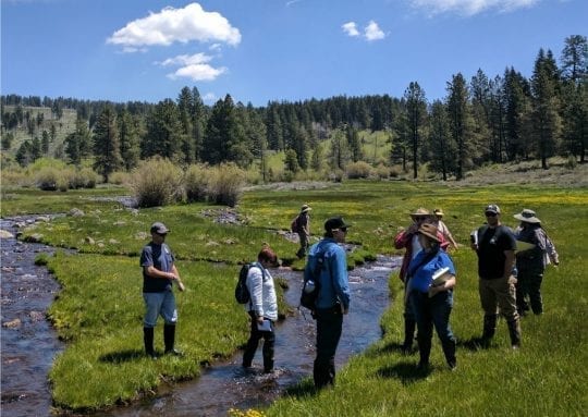
Officially launched in June 2017, the project began with an assessment of meadow conditions across the watershed. Levi Keszey from CalTrout’s Sierra Headwaters office trained working group members to use the American Rivers Rapid Meadow Assessment Scorecard in the field. The AR Scorecard method is both rigorous and accessible to non-specialists, making it an efficient way to evaluate conditions on the ground. The scorecard results in a score (out of 100) indicating the health of the meadow and collects important data that can be used to prioritize meadows and indicate which issues restoration needs to address. Meadow assessment also provides an organized database of meadows in the watershed that can be used in planning further restoration projects beyond this one.

AR scorecard training at Parsnip Springs Meadow in the South Warner Mountains (Photo by Phoenix Isler)
Restoring over a century of degradation
Meadows in this area have become degraded by more than a century of land use impacts including overgrazing, water diversion, and forestry practices. Healthy meadows provide important hydrologic functions by spreading and slowing flows during the wet season and storing groundwater that is slowly released as cool flows in late summer. An eroded stream in a degraded meadow drains winter rains and snowmelt quickly downstream as the channel is no longer connected to the floodplain. This can lead to a drop in the water table as the “sponge” of the meadow is dried out. Invasive species and upland conifers and shrubs can encroach on the meadow and take over.
Restoration goals include returning hydrologic function, and enhancing habitat for terrestrial and aquatic species including migratory birds and native fish (Rainbow Trout and the Modoc Sucker). Restoring meadows in the Upper Pit Watershed can improve groundwater recharge and late-season base flows and benefit water quality in the Pit River by moderating flood events and reducing sediment loads.
Over the summer, multi-stakeholder teams assessed a total of 35 meadows with an area totaling over 5,000 acres. Assessment scores ranged from 47 to 98, showing some healthy meadows and others in bad shape.
Nearly all the assessed meadows had evidence of grazing, although some meadows in the Modoc National Forest scored highly despite being grazed for some part of the year, demonstrating that when appropriately managed, grazing can take place in meadows without causing erosion and degradation.
The next step was prioritization, ranking meadows based on the scorecard results and other criteria including habitat diversity and complexity, importance to the Pit River, feasibility for successful restoration, and “bang for the buck.” The process identified four priority meadows to be restored – two in the Modoc National Forest, one on private land, and one meadow split between Bureau of Land Management and California Department of Fish and Wildlife ownership.
Priority meadows for restoration

Fitzhugh Creek Meadow lies partially on BLM land and partially in the CDFW Fitzhugh Creek Wildlife Area, and contains a stream with good fish habitat and moderate channel incision. This meadow could be restored using beaver dam analogues (BDAs), low-cost structures that mimic what beavers build to slow down flows and create pools in deeper parts of the channel. BDAs can be easily built by hand crews using natural materials, and the most exciting part is that if there are beaver present in the area, they are likely to move in to the newly created habitat and maintain it with their own constructions.
The 120-acre Patterson Meadow sits in the foothills of the South Warner Mountains in the Modoc National Forest and has multiple head cuts (newly eroding channels) threatening to open up in the middle of the meadow. It is not yet severely degraded but is at risk due to the head cuts, so is high-priority for restoration.
Willow Creek Meadow is located on private land in an area with high habitat diversity and complexity including healthy stands of willows and aspens. The channel has been seriously eroded, with bank heights of over 6 feet. The “pond and plug” technique is likely to be applied in this meadow, requiring a relocation of the main channel and replacing the eroded channel with a series of earth plugs and dug out ponds.
Parman Meadow in the Warner Mountains northeast of Alturas is a special site because it contains fens – an uncommon habitat type comprised of peat wetlands, home to rare moss and plant species. This meadow has been trampled by cattle, cutting channels in the delicate peat. It presents an opportunity to learn more about how to restore fens by trialing new techniques to determine what is most effective.
While this project focuses on only four meadows, it is part of a larger vision for increasing the pace and scale of meadows work in this region. The data gathered during assessment will be useful to other groups looking to pursue similar projects. Now that target meadows have been identified, work is proceeding on restoration design, and in 2018 we will go through the state or Federal environmental compliance processes and apply for funding for the implementation phase of the project.


1 Comment
Any advance planning for 2019 re: Restoring Modoc Meadows? I may be able to assist.