CalTrout Beginning Restoration Projects on Hat Creek, Fall River
“Given our history and connection to these streams, CalTrout feels a strong responsibility to reverse the current decline”
by Drew Braugh, Mt. Shasta Conservation Manager
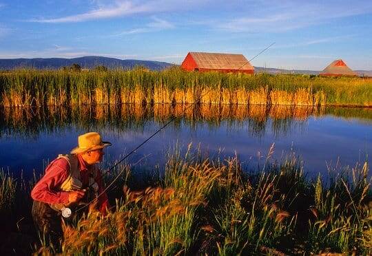
Few streams typify the “spring creek” fly fishing experience better than Northern California’s Hat Creek and the Fall River. Known for their crystal clear water, exceptional scenery, and challenging angling, these streams exemplify what spring creek fisheries are all about.
In 1971, CalTrout worked with the Department of Fish and Game to designate Hat Creek as the state’s first protected “Wild Trout Area” (WTA). Thanks to the new management guidelines set up under the WTA, Hat Creek quickly became one of California’s most productive fly fishing waters and notable accomplishments in CalTrout’s 40-year history.
Unfortunately, now more than 40 years later, habitat conditions in both Hat Creek and the Fall River have once again begun to deteriorate. Both rivers are suffering from habitat degradation caused by over- sedimentation and the collapse of native aquatic plants.
Sedimentation, Plants Causing Decline
In the Fall River, invasive Eurasian watermilfoil continues to outcompete and overtake native aquatic plants, which in turn negatively affect macroinvertebrate food sources and overall fish populations.
In sizeable areas of Hat Creek, aquatic vegetation has almost completely disappeared, taking with it important sources of food and shelter.
Given our history and connection to these streams, CalTrout feels a strong responsibility to reverse the current decline. This summer, we plan to begin a comprehensive long-term campaign to restore these fisheries by improving critical habitat, managing invasive species and installing monitoring systems that will track changes in conditions over time.
The purpose of this effort is to protect the extraordinary recreational and ecological values of Northern California’s most important “spring creek” wild trout fisheries – Hat Creek and Fall River – for future generations.
In both cases, CalTrout is working to bring together a group of public and private stakeholders to develop viable long-term solutions.
For Hat Creek, these stakeholders, known as the Hat Creek Resource Advisory Committee (Hat RAC), include the California Department of Fish and Game, PG&E, the UC Davis Center for Watershed Sciences, the Regional Water Quality Control Board and other key groups.
Restoration Efforts Underway
Already, the Hat RAC has developed a draft restoration plan and secured over $100k for implementation and monitoring.
On the Fall River, we will be partnering with the newly formed Fall River Conservancy (FRC).
Together, CalTrout and FRC are designing a two-year pilot program that will utilize the milfoil weevil (small beetle) as a biological control for managing highly invasive Eurasian watermilfoil found throughout the Fall River.
Over the next two years, CalTrout aims to restore more than 15 miles of spring-fed, cold-water habitat in Hat Creek and the Fall River while boosting wild trout populations by more than 1,000 fish per mile/per stream.
Additionally, we will monitor water quality for specific parameters including temperature, dissolved oxygen, bacteria and excessive nutrient loading.
To read more about our efforts to protect Hat Creek and the Fall River visit our website at caltrout.org/initiatives/blue-ribbon-waters.


6 Comments
The article states the problem but doesn’t go into much detail on the causes. Why is the vegetation nearly gone in some parts of Hat Creek? How did the Eurasian watermilfoil get in the Fall River in the first place and what is causing over sedimentation? Cal Trout will spend lots of money restoring these waters but what is being done to stop the cause of the degradation in the first place?
-Trev
The sedimentation in Hat Creek results from a Baum Lake Canal side wall rupture that cascaded the entire creek down the mountainside and into its (now dry) ancestral channel. Because of the rigid control of flows from the Powerhouse feeding the creek – the water flow is kept constant regardless of rainfall and season.
The natural cleansing and scour that comes with winter flooding cannot because the flow is regulated, therefore the slug of silt that came with the breach sits their immovable.
A couple decades of anglers feet in the Powerhouse #2 riffle hasn’t helped either – nearly 50 feet of bank was sent into the creek by all those feet climbing in and out of the water. The bank has been stabilized now, with boulders and saplings, but if the creek regains its former glory – those thousands of feet will return, and they’ll be wearing cleated rubber soles – which will tear hell out of the banks.
Thank you for your interest in Hat Creek and the Fall River. Most of the problems facing both of these streams–especially sediment issues–originated with historic land use patterns from the early 20th century, which include channel straightening, timber harvest practices, livestock management, and hydropower development.
Hydropower construction began in the 1920’s on both Hat Creek and the Fall River. In Hat Creek especially, these operations caused major disruptions in natural geomorphic processes and sediment supply. Unfortunately, we do not yet know the exact cause of the degraded aquatic vegetation in Hat Creek. One possibility, however, is that hydropower operations have dramatically altered sediment supply, which in turn is impacting the substrate that certain plants rely on for survival.
What are we doing about it? Caltrout is facilitating a restoration group that includes the UC Davis Center for Watershed Sciences, CA DFG, Regional Water Quality Control Board, the Fall River Conservancy, PGE, Spring Rivers Ecological Consultants Inc, and others. This group is currently assessing the problem, identifying root causes, and designing solutions. PGE and Shasta County have committed significant funding for restoration. Given the permanent nature of major hydropower infrastructure, it’s unlikely that natural geomorphic processes can be restored in the short term. Consequently, we’re faced with the challenge of reconciling our conservation objectives with the realities of growing energy and water demands in California.
What can we do? Caltrout believes that viable solutions exist for restoring Hat Creek. First, we can place large woody debris in the Wild Trout Area above highway 299. Large woody debris will provide much needed cover and depth for wild trout. Second, we can manage muskrat populations. Muskrats cause excessive sedimentation by collapsing stream banks. Third, we can actively restore stream banks and channel morphology by planting native aquatic vegetation in key locations such as Wood Duck Island and Carbon Bridge. Combined, these strategies will provide habitat for wild trout, improve geomorphic processes, and possibly begin to restore substrate and aquatic vegetation. Finally, we can work with our partners to establish a full scale monitoring system that will help us measure our effectiveness and document changes in the health of the river over time.
As for Eurasian watermilfoil (EWM) in the Fall River, EWM was introduced to the U.S. in the early 20th century and has been spreading across the U.S. ever since. Some say EWM was first found in the Chesapeake Bay in 1880’s. Interestingly, EWM has been working its way across the U.S.: Wisconsin in the 1960’s, Washington state in 1970’s, Utah in 1993, and finally the Fall River in 1998. Nobody is sure how it arrived in the Fall River but possible explanations include boat propellers, anglers, recreationalists, and even Mother Nature.
Andrew,
That’s all fine and well, but that gigantic slug of sediment has turned the upper river into a much shallower stream than it used to be, and therefore simply planting weeds on the bottom will not restore the balance of nature.
Carbon bridge alone was shoulder deep when you stepped off the bank, and there was no way you could wade across the river. Now it’s a bit more than three feet deep in most of the area – and that lack of water depth should make the creek both warmer – and the fish more susceptible to osprey predation.
Weeds will add bugs – bugs will add fish, but the large trout won’t be safe given the water depth – and will quickly vanish once they get tired of wading anglers stomping into their lie.
Don’t you plan on siphoning some of that enormous slug of silt off the bottom – and similar treatment at the Britton Weir – where its mounded in dunes like the Sahara desert?
It’s not only shallower, it’s a lot wider (noticeably wider than the first time I fished it). That slows the water, drops the sediment, and results in an even shallower creek.
Muskrats are the chief thing eroding the banks (look just downstream of the old bank erosion project and see several feet of bank gone).
Muskrat control has got to be high on the list of things to do.
I think everyone is missing the point on the spread of Milfoil in the Fall River.
Milfoil is spread by fragmentation. A single fragment of Milfoil can produce
250 millon plants a year.
The number of fragments put into the water by boats pulling their anchors in and out is uncountable.
The fisheman need to change their method of fishing the river until the Milfoil is controlled.
Drift fishing without anchoring would be the single best way to help control the spread of Milfoil.